
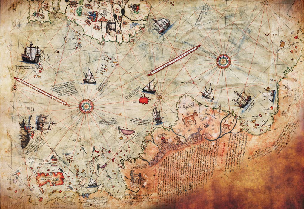
May is Map Month at Aesthetic Triangle and what better way to start than with the beautiful Piri Reis Map? Crafted in the early 16th century by the Ottoman cartographer and admiral Piri Reis, this remarkable map offers a unique perspective on the world as seen through the eyes of Renaissance explorers. With its intricate details, mysterious symbols, and controversial claims, the Piri Reis Map continues to captivate scholars and enthusiasts alike, inviting us to unravel the mysteries of the ancient world.
The Piri Reis Map is part of a larger work known as the Kitab-ı Bahriye, or Book of Navigation, compiled by Piri Reis in 1525. The map itself is a portolan chart—a type of navigational map used by sailors to navigate coastal waters and navigate safely between ports. What sets the Piri Reis Map apart, however, is its inclusion of geographical features and regions far beyond the traditional scope of portolan charts, including parts of the Americas, Africa, and Antarctica.
One of the most controversial aspects of the Piri Reis Map is its depiction of Antarctica. According to some interpretations, the map shows the coastline of Antarctica with a remarkable level of accuracy—a feat that would have been impossible for Renaissance cartographers given the limited knowledge of the continent at the time. Some researchers have speculated that the map’s depiction of Antarctica is evidence of ancient seafaring voyages or knowledge of the continent’s existence long before it was officially discovered in the 19th century.
Another mystery surrounding the Piri Reis Map is its inclusion of South America and the Caribbean. The map shows the coastlines of South America and the Caribbean with surprising accuracy, including the Gulf of Mexico and the Amazon River. Some have suggested that Piri Reis may have drawn on earlier maps or sources of information, possibly from pre-Columbian or Viking explorations of the Americas, to create his map.
Despite the controversies surrounding the Piri Reis Map, scholars have offered various interpretations and explanations for its unusual features. Some argue that the map’s depiction of Antarctica is purely coincidental and the result of inaccuracies or artistic license on Piri Reis’ part. Others suggest that the map may have been based on earlier maps or sources of information that have since been lost or destroyed.
Another interpretation is that the Piri Reis Map reflects the state of geographical knowledge and speculation during the Renaissance era. At a time when European explorers were venturing into uncharted territories and encountering new lands and peoples, maps like the Piri Reis Map served as tools for navigation, exploration, and discovery. While not always accurate or reliable by modern standards, these maps provided valuable insights into the worldview and aspirations of Renaissance cartographers and explorers.
Regardless of its origins and accuracy, the Piri Reis Map holds significant historical and cultural value as a testament to the spirit of exploration and discovery that characterized the Renaissance era. It serves as a reminder of the ongoing quest to explore and understand the world around us, as well as the enduring fascination with maps as artifacts of human knowledge and imagination.
The Piri Reis Map also highlights the interconnectedness of cultures and civilizations across time and space. As a product of the Ottoman Empire, the map reflects the cosmopolitan outlook and cultural exchange that characterized the Mediterranean world during the Renaissance. It reminds us that the pursuit of knowledge and discovery knows no boundaries and that maps have the power to transcend language, culture, and geography.
This lovely Map remains a captivating and enigmatic artifact that continues to inspire curiosity and speculation centuries after its creation. Whether viewed as a work of art, a navigational tool, or a window into the past, the map invites us to explore the mysteries of the ancient world and the enduring legacy of human exploration and discovery. As we unravel the secrets of the Piri Reis Map, we gain a deeper appreciation for the complexities of cartography and the timeless quest to chart the unknown.
#PiriReisMap #AncientCartography #Exploration #History #LostMaps
