
Our month of May focus on maps continues and would not be complete without a post about T and O maps. T and O maps stand as iconic representations of the world’s geography and cosmology. Dating back to antiquity but reaching their zenith in the Middle Ages, these maps offer a unique window into the medieval worldview, blending religious symbolism with geographical knowledge. Through their distinctive design and symbolism, T and O maps provide valuable insights into how medieval Europeans perceived and navigated the world around them.
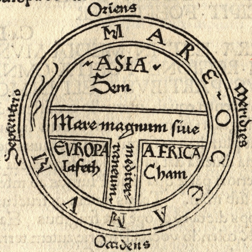
At first glance, T and O maps may appear simplistic, with their circular design and cruciform layout. However, these maps were far more than mere visual representations of the world—they were intricate cosmological diagrams infused with religious symbolism and philosophical meaning. At the center of each map lies a T-shaped cross, representing the intersection of the three continents known to medieval Europeans: Asia, Europe, and Africa. Surrounding the cross is a circular ocean, symbolizing the known world and the boundaries of human knowledge.
The symbolism of T and O maps extends beyond their visual design to their navigational function. In addition to representing the continents and oceans of the world, these maps were used as tools for orientation and navigation, helping travelers and explorers find their way in an uncertain world. By orienting themselves with respect to the cardinal directions—north, south, east, and west—medieval navigators could use T and O maps to chart their course and navigate the seas with greater confidence.
Yet, for all their symbolism and navigational utility, T and O maps were not intended to be accurate representations of the physical world. Instead, they were symbolic representations of the cosmos, reflecting the medieval worldview and its blending of religious beliefs, philosophical ideas, and geographical knowledge. The T-shaped cross at the center of each map symbolized the Christian faith and the salvation of humanity through the death and resurrection of Jesus Christ, while the circular ocean represented the divine order and harmony of the cosmos.
One of the most intriguing aspects of T and O maps is their depiction of the world’s geography and cosmology. While medieval Europeans had limited knowledge of the world beyond their own continent, T and O maps offered a comprehensive view of the known world, with Asia to the east, Europe to the west, and Africa to the south. Surrounding the known world was a vast ocean, beyond which lay unknown lands and mythical realms—a reminder of the mysteries and wonders that awaited discovery beyond the boundaries of human knowledge.
Despite their symbolic and philosophical significance, T and O maps were practical tools for navigation and exploration. By providing travelers with a visual representation of the world’s geography and cosmology, these maps helped them navigate the seas and explore distant lands with greater confidence. From the ancient mariners of antiquity to the medieval explorers of the Age of Discovery, T and O maps played a vital role in shaping the course of human history and expanding our understanding of the world.
T and O maps represent a fascinating fusion of religious symbolism, philosophical thought, and geographical knowledge. Through their distinctive design and symbolism, these maps offer valuable insights into the medieval worldview and its blending of faith, reason, and exploration. As we decipher the symbolism and navigation of T and O maps, we gain a deeper appreciation for the rich tapestry of ideas and beliefs that shaped medieval cartography and our understanding of the world.
#TandOMaps #MedievalCartography #Symbolism #Navigation #MiddleAges
