
For those interested in cartographic history, few works loom as large as the Ptolemaic Map. Crafted in the 2nd century AD by the Greco-Egyptian geographer Claudius Ptolemy, this seminal work represents a landmark achievement in the history of geography—a comprehensive atlas that synthesized the geographical knowledge of the ancient world and laid the groundwork for centuries of mapmaking and exploration. Rediscovered and translated during the Renaissance, the Ptolemaic Map sparked a renewed interest in ancient geography and paved the way for the Age of Discovery—a testament to the enduring legacy of ancient scholarship and the timeless quest for knowledge.
At its core, the Ptolemaic Map is a remarkable synthesis of empirical observation, mathematical precision, and speculative geography. Drawing upon a wide range of sources including earlier maps, travelogues, and astronomical observations, Ptolemy sought to create a comprehensive atlas that would encompass the known world and provide a systematic framework for understanding its geographical features and relationships. The resulting work, known as the “Geographia,” consists of eight books containing maps, geographical coordinates, and descriptive texts that span the breadth of the ancient world—from Spain to India, from Scandinavia to the Horn of Africa.
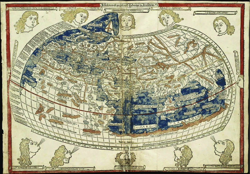
One of the most revolutionary aspects of the Ptolemaic Map is its use of a grid system of latitude and longitude—a concept that would become foundational to modern cartography. By dividing the Earth’s surface into a grid of intersecting lines, Ptolemy provided a method for accurately representing geographical locations and distances—a groundbreaking innovation that revolutionized the way we conceptualize and navigate the world. Through his meticulous calculations and mathematical rigor, Ptolemy laid the groundwork for centuries of mapmaking and exploration, setting the stage for the age of discovery that would follow.
Equally impressive is the map’s portrayal of the world as it was understood in antiquity. While modern viewers may find its geography outdated and its borders unfamiliar, the Ptolemaic Map nonetheless offers valuable insights into the geographical knowledge and cultural perceptions of the ancient world. From the winding course of the Nile to the rugged mountains of Central Asia, the map reflects the cartographic conventions and geographical misconceptions of its time, as well as the diversity and complexity of the known world.
Yet, for all its historical significance, the Ptolemaic Map also serves as a testament to the enduring power of human curiosity and the quest for knowledge. Rediscovered and translated during the Renaissance, Ptolemy’s work sparked a renewed interest in ancient geography and inspired generations of explorers, cartographers, and scholars to chart new territories and expand the boundaries of human knowledge. From the voyages of Christopher Columbus to the expeditions of Marco Polo, the legacy of the Ptolemaic Map reverberates through the ages, shaping the course of history and inspiring future generations to explore the unknown.
Among other things, this map stands as a testament to the enduring legacy of ancient scholarship and the timeless quest for knowledge. Through its meticulous calculations, mathematical precision, and geographical insight, Ptolemy laid the groundwork for centuries of mapmaking and exploration, revolutionizing the way we conceptualize and navigate the world. As we rediscover its ancient geography and cultural significance, we gain a deeper appreciation for the enduring legacy of the Ptolemaic Map and the timeless quest for knowledge that continues to inspire us to explore the unknown.
#PtolemaicMap #AncientGeography #Cartography #History #Geography
