
In the vast annals of ancient cartography, few artifacts stand as remarkable testaments to human ambition and ingenuity as the Peutinger Table. This enigmatic document, dating back to the late Roman Empire, offers a unique glimpse into the vast network of roads and routes that crisscrossed the ancient world. From the shores of Britannia to the banks of the Euphrates, the Peutinger Table serves as a captivating window into the logistical marvel that was the Roman Empire.
Commissioned in the 4th or 5th century AD, the Peutinger Table is a medieval copy of an ancient Roman map that traces the major roadways of the empire. Unlike conventional maps, it is not drawn to scale but rather as a linear depiction of the Roman road network, resembling a modern strip map. Measuring over 22 feet in length when fully assembled, it is a remarkable feat of cartographic preservation, offering a wealth of information about the ancient world.
At first glance, the Peutinger Table may appear bewildering to modern eyes, with its elongated shape and stylized depictions of cities, rivers, and landmarks. Yet, beneath its surface lies a wealth of geographical and historical detail, meticulously arranged to facilitate travel and communication across the far-flung corners of the empire. From military outposts to bustling market towns, every settlement is meticulously labeled, reflecting the administrative and logistical infrastructure of Roman rule.
One of the most striking features of the Peutinger Table is its depiction of the Roman road network, which served as the lifeblood of the empire. Stretching over 70,000 miles at its zenith, these meticulously engineered highways facilitated the movement of troops, goods, and ideas across vast distances, linking the disparate provinces of the empire into a cohesive whole. From the Appian Way to the Via Egnatia, these ancient arteries connected Rome to its distant frontiers, enabling the rapid transmission of people and information.
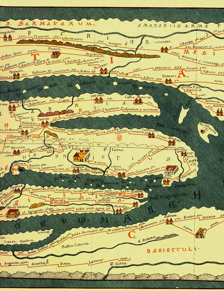
Equally fascinating is the Table’s portrayal of the diverse peoples and cultures that inhabited the Roman world. From the Celtic tribes of Gaul to the nomadic tribes of the Syrian desert, the map offers a glimpse into the rich tapestry of human civilization that flourished under Roman rule. Through its depiction of cities, forts, and landmarks, it invites viewers to embark on a virtual journey through time and space, exploring the sights and sounds of an empire at its zenith.
Yet, for all its historical significance, the Peutinger Table remains a document shrouded in mystery and intrigue. Its origins and purpose are still the subject of scholarly debate, with historians speculating about its intended audience and the motivations behind its creation. Some believe it was produced for military or administrative purposes, while others suggest it may have served as a prestige object for a wealthy patron or as a practical guide for travelers.
Regardless of its original intent, the Peutinger Table stands as a testament to the enduring legacy of the Roman Empire and its impact on the course of human history. Through its intricate details and geographical precision, it offers a captivating glimpse into the world of antiquity, inviting viewers to marvel at the achievements of a civilization that once spanned three continents. As we trace the routes and roads of the ancient world, we are reminded of the enduring power of maps to illuminate our understanding of the past and to connect us to the legacies of those who came before.
The Peutinger Table remains a fascinating relic of the Roman Empire—a testament to the ingenuity and ambition of an ancient civilization. Through its detailed depiction of roads, cities, and landmarks, it offers a captivating glimpse into the interconnectedness of the ancient world, inviting viewers to embark on a virtual journey through time and space. As we marvel at its intricate details and historical significance, let us also reflect on the enduring legacy of the Roman Empire and its impact on the course of human history.
#PeutingerTable #RomanEmpire #AncientCartography #History #Infrastructure
