
In the era of the Age of Exploration, where daring voyages and unprecedented discoveries reshaped the world map, the Cantino Planisphere stands as a remarkable artifact that encapsulates the spirit of adventure, curiosity, and discovery of the time. Crafted in the early 16th century by an unknown Portuguese cartographer, this exquisite map offers a tantalizing glimpse into the geographical knowledge, maritime routes, and exotic lands known to Europeans during the Age of Discovery. With its intricate details, vivid illustrations, and historical significance, the Cantino Planisphere remains a testament to the remarkable achievements and enduring legacy of the Age of Exploration.
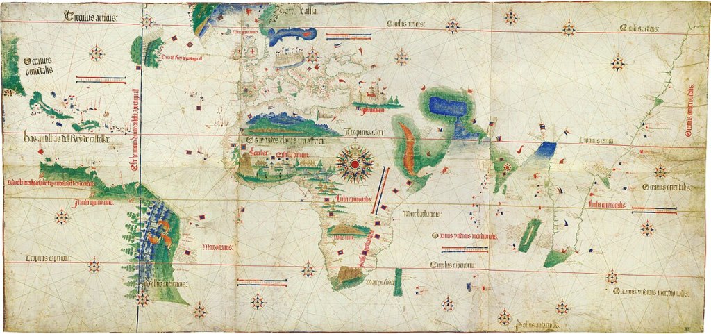
Commissioned by Alberto Cantino, an Italian diplomat in the service of the Duke of Ferrara, the Cantino Planisphere is believed to have been created around 1502-1504. Designed to showcase the latest geographical discoveries of Portuguese explorers, the map features a wealth of information about the newly discovered lands, including coastlines, rivers, cities, and navigational routes. One of the most striking features of the Cantino Planisphere is its depiction of the newly discovered coastlines of Africa, Asia, and the Americas, which were previously unknown to Europeans.
At the heart of the Cantino Planisphere lies the Portuguese empire, depicted with meticulous detail and precision. From the bustling ports of Lisbon and Porto to the distant shores of Africa and Asia, the map offers a vivid portrayal of Portugal’s maritime expansion and global reach during the Age of Exploration. Surrounding Portugal are various regions and kingdoms of Africa, Asia, and the Americas, each represented with distinctive symbols and annotations that highlight their geographical features and strategic importance in the global trade network.
One of the most intriguing aspects of the Cantino Planisphere is its depiction of the newly discovered lands of the Americas. The map shows the coastlines of South America and the Caribbean with remarkable accuracy, including the islands of Cuba, Hispaniola, and Jamaica. This depiction reflects the latest geographical knowledge available to Europeans at the time and provides valuable insights into the early exploration and colonization of the New World.
Another notable feature of the Cantino Planisphere is its depiction of the Indian Ocean and the maritime routes to Asia. The map shows the coastlines of Africa, Arabia, and India, as well as the Spice Islands of Southeast Asia, which were highly coveted for their valuable spices and luxury goods. This depiction reflects Portugal’s efforts to establish direct trade routes to Asia and bypass the overland trade routes controlled by the Ottoman Empire and other intermediaries.
The Cantino Planisphere’s impact extended far beyond the Age of Exploration, influencing subsequent generations of cartographers, explorers, and historians. Copies of the map circulated widely throughout Europe, serving as a valuable reference for scholars, merchants, and navigators seeking to understand the geography of the newly discovered lands and navigate the treacherous waters of the Atlantic and Indian Oceans. Today, the Cantino Planisphere remains a cherished artifact that offers a unique window into the geographical knowledge, maritime routes, and global trade networks of the Age of Exploration.
The Cantino Planisphere represents the enduring spirit of adventure, curiosity, and discovery that characterized the Age of Exploration. In an era of unprecedented exploration and discovery, the Cantino Planisphere served as a beacon of hope and inspiration for generations of explorers, navigators, and adventurers seeking to chart new territories, discover new lands, and expand the boundaries of human knowledge.
#CantinoPlanisphere #AgeofExploration #PortugueseEmpire #NewWorld #GlobalTrade
