
The Tabula Rogeriana, a masterpiece crafted by the renowned Arab geographer Muhammad al-Idrisi in the 12th century. Commissioned by King Roger II of Sicily, this extraordinary map represents a culmination of geographical knowledge from diverse cultures and civilizations, offering a comprehensive and remarkably accurate depiction of the known world at the time. With its meticulous attention to detail, innovative design, and cultural synthesis, the Tabula Rogeriana remains a testament to the enduring legacy of medieval cartography.
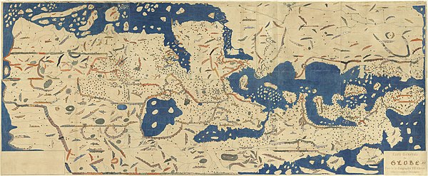
At the heart of the Tabula Rogeriana lies al-Idrisi’s meticulous compilation of geographical information gathered from sources spanning the ancient world, including Greek, Roman, Arab, and Persian texts. Drawing upon these diverse sources, al-Idrisi meticulously crafted a map that not only represented the physical geography of the world but also incorporated cultural, historical, and ethnographic details, making it a true reflection of the cosmopolitan spirit of the medieval Mediterranean.
One of the most remarkable features of the Tabula Rogeriana is its innovative projection technique, which employed a circular map divided into seven climate zones—a departure from the traditional rectangular maps of the time. This unique projection allowed al-Idrisi to represent the curvature of the Earth more accurately and present a more realistic depiction of the world’s continents, oceans, and geographic features.
The Tabula Rogeriana is also distinguished by its inclusion of detailed geographic and ethnographic information, including the names of cities, rivers, mountains, and regions, as well as descriptions of the customs, languages, and cultures of various peoples around the world. Through his meticulous research and synthesis of diverse sources, al-Idrisi created a map that not only served as a navigational aid but also as a window into the rich tapestry of human civilization.
Beyond its practical utility, the Tabula Rogeriana holds symbolic and cultural significance as a representation of the cosmopolitan and multicultural nature of the medieval Mediterranean world. As a product of the cultural exchange and intellectual ferment that characterized the region during the Middle Ages, the map embodies the spirit of cross-cultural collaboration and dialogue that flourished in medieval Sicily under King Roger II’s patronage.
The Tabula Rogeriana’s impact extended far beyond the medieval period, influencing subsequent generations of cartographers and explorers and shaping European perceptions of the world. Copies of the map circulated widely throughout the Islamic and Christian worlds, serving as a valuable reference for scholars, travelers, and merchants seeking to navigate the intricacies of the medieval world.
As we reflect on the legacy of the Tabula Rogeriana, we are reminded of the enduring power of cartography to transcend boundaries, bridge cultures, and expand our understanding of the world. In an age of increasing globalization and interconnectedness, the Tabula Rogeriana serves as a timeless reminder of the importance of dialogue, cooperation, and mutual understanding in shaping our shared future.
#MedievalCartography #TabulaRogeriana #Idrisi #KingRogerII #CulturalSynthesis
